~ Article written and pictures taken by Linda Grace,
Publicity Clerk, Old Forge Visitor Information Center.
Mid-September was the
start of bear hunting season, and now the deer hunters are out trying to get
their game. Hunting season lasts long into December. I truly respect hunters
and understand the need for them in our back country, but as a hiker and trail
runner, I find this season difficult. I know I can, and often do, run the roads
during this time. Still, there is something about my mornings beginning in the
wilderness which just makes my day. I realize that there are others who feel
the same way and so I have decided to write about trails which will help us
keep a respectable distance from hunters.
Town-owned McCauley
Mountain to Maple Ridge offers a multi-use trail system, with biking and hiking
for three of our four seasons and it offers cross-country skiing and
snowshoeing in the winter. This means that there is no hunting here, and in the
winter there are no snowmobiles.
 |
I must admit that I
really didn’t like the thought of this maze-like array of trails, because I am
the kind of person who really likes to go somewhere and see something. The area at first seems a little confusing,
and it definitely calls for a use of a map, as well as keeping a careful eye
out for trail markers. After studying the map of the area, I realized that
there are only two main trails with many side trails weaving in and out of them.
I decided I’d at least
give the two main trails a try. Have you ever seen a movie trailer that
features all the best scenes of the movie? Well this blog is kind of like that.
I describe the best of this hike right here, but I am not like those writers
who give people every detail of the hike. I like to leave some things for the
adventurers to discover for themselves.
 |
| Gray Lake |
Following the signs to McCauley
Mountain, drive past a parking area and garage on the left. The trail begins on
the left shortly after the brown Yurt. The blue diamond trail
and the yellow trail start off together. I decided to follow the yellow trail,
which is called The Wall, going in a northeastern direction, and then winding
around to go west to the Grey Lake Trail. After a short ascent heading north
again, the fall colors were at about 30 percent on the day of my hike. I
thought the trail wouldn’t give me a view of anything but trees, but it opened
up and offered a colorful vista of Grey Lake.
I followed Slalom Trail
then began following the blue diamond trail up Boy’s Hill and started up a
small incline of the Abenaki Trail. After the hike up the hill, I was rewarded
with a picnic table and some Adirondack chairs perfect for a rest. They face a
tree line offering glimpses of McCauley’s downhill slope. This area is also near
where they had the slalom ski run, although it is hard to tell, because of all
the tree growth.
 |
| The old truck at the top of Abenaki Trail |
I continued up this
trail and got to see historic ski tow equipment. People who grew up here have
the advantage of hearing the stories from past generations, so I picked some
brains about the old time tows. I also did some research on line and in the
library. What I learned is that the tow was created by attaching a rope to the
axle of an old truck’s wheels after the truck was mounted securely. As someone
ran the truck, the truck’s wheel axle would turn and become the pulley for the
tow rope. One year after obtaining their first tow rope, the Old Forge Winter
Sports Association voted to get another tow line. Old Forge Hardware provided
the rope and the equipment. The old truck used to run the second tow line is
the one which remains on the top of Abenaki Trail today.
After visiting this
historic truck, I continued following the McCauley Trail around where it joins
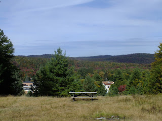
up to Mocha’s Loop and goes over to the former Maple Ridge ski hill. This ski
area was started in the 1930’s with a single rope tow. The town continued using
this mountain for downhill skiing into the 1990’s. There is equipment left
here, as well, that tells of the bygone era.
 |
| Ski equipment at the top of Maple Ridge |
I followed the Maple
Ridge yellow/orange trail to the Girl’s Hill and took the D Loop cutoff and
Reggie’s Loop Cutoff and back to the blue diamond McCauley Trail back to my
starting point.
To say the least, my
original opinion of this area has changed. I now see it as a good getaway, with
the option of a full-day, partial-day or short hike into a quiet place in the
woods.
[For more information on
Maple Ridge, one can read the book Lost Ski Areas of the Adirondacks by
Jeremy K. Davis.]
How to get there: From Old Forge follow the signs to McCauley Mountain. Park at the closed gate and walk on paved driveway pass the brown yurk on the left and trail is on the left.
 |
| Yurk |
 |
| Trail head from McCauley enterance |
 |
| Top of Maple Ridge overlooking Old Forge |
This trail system offers easy to moderate trails ranging from half a mile to 1.5 miles. For a map of this area click below:
http://www.oldforgeny.com/documents/WARDAMapofMapleRidge.pdf